


 Newsroom
 Η διαδρομή αυτή που διοργανώθηκε από τους φίλους του Πάρκου Πάρου στο πλαίσιο διήμερων εκδηλώσεων αφιερωμένων στο Φάρο του Κόρακα, ήταν μια πεζοπορική περιήγηση με μεγάλο ενδιαφέρον.
Οι συμμετέχοντες ενημερώθηκαν στη διάρκεια της πορείας τους για την ιδιαίτερη χλωρίδα της περιοχής αλλά και τα γεωλογικά στοιχεία της, χάρηκαν το φυσικό τοπίο, εξερεύνησαν περπατώντας το ανάγλυφο του χώρου, ήρθαν σε επαφή με το φυσικό περιβάλλον του τόπου, καταλήγοντας τελικά στο Φάρο του Κόρακα.
Εκεί τους περίμενε ο φαροφύλακας ο οποίος και έκανε την ξενάγηση στο Φάρο.
To psts.gr σας παρουσιάζει ένα βίντεο από την πραγματικά όμορφη αυτή δραστηριότητα που συνδύασε την αναψυχή με τη γνώση και την επαφή με το πολιτισμικό παρελθόν της περιοχής.
Το μονοπάτι ως «ομιλούσα οδός»: Μια απογευματινή οικοπεριήγηση στο Πάρκο Πάρου
Φθάνοντας στο Πάρκο, στο τέλος του δρόμου προς τις Κολυμπήθρες, συναντάμε τα καρνάγια, το Μοναστήρι του Αϊ - Γιάννη Δέτη, την οργανωμένη παραλία του Καθολικού με το σνακ-μπαρ, καθώς και το υπαίθριο θέατρο κτισμένο στα βράχια και τον εκθεσιακό χώρο, όπου φιλοξενούνται μουσικές εκδηλώσεις, εκθέσεις, διαλέξεις και προβολές.
Όταν διασχίζεις την χερσόνησο του Αϊ - Γιάννη του Δέτη είναι σαν να διανύεις μία διαδρομή που ξεκινά από την προϊστορική εποχή και καταλήγει στο τέλος του 19ου αιώνα όταν υψώθηκε ο πετρόκτιστος φάρος στο βορειότερο κάβο του νησιού, τον Κόρακα.
Οι πολλές κοντινές και μακρινές αμμώδεις παραλίες του Πάρκου, οι μικροί όρμοι και οι σπηλιές, αλλά και ο Φάρος στον Κάβο–Κόρακα και τα ερείπια των εγκαταστάσεων του στόλου των Ρώσων στα Ορλωφικά (1770-1774), προσεγγίζονται μέσα από μονοπάτια κατάλληλα για κάθε ηλικία., οργανωμένα σε επτά πεζοπορικές διαδρομές 7 χλμ. περίπου.
Ένα από τα μονοπάτια αρχίζει από την αυλή του μοναστηριού του Αϊ - Γιάννη του Δέτη. Το τοπωνύμιο αναφέρεται ήδη από το 1530 στους χειρόγραφους πορτολάνους. Το 1833, με νόμο της Αντιβασιλείας του Όθωνα, το μοναστήρι εγκαταλείπεται από τους μοναχούς. Το μοναστήρι πανηγυρίζει στις 29 Αυγούστου, ημέρα αποτομής της κεφαλής του Αγίου Ιωάννη του Προδρόμου. Το προσωνυμία «Δέτης» προήλθε από την ιδιότητα του Αγίου να «δένει» (θεραπεύει) την ελονοσία, που το 18ο και το 19ο αιώνα ταλαιπωρούσε τους κατοίκους της Νάουσας.
Το μονοπάτι 1 συνεχίζει στην απέναντι πλευρά του ασφαλτόδρομου και ανηφορίζει ομαλά στο χαμηλό λόφο δυτικά του μοναστηριού. Στη θέση αυτή, που παρέχει δυνατότητα ελέγχου της εισόδου του κόλπου της Νάουσας, αποκαλύφθηκαν λείψανα κτισμάτων οικιστικής εγκατάστασης που χρονολογούνται στην πρώιμη αρχαϊκή περίοδο.
Αφού παρακάμψουμε το μικρό λόφο στο βορρά, κατηφορίζουμε βλέποντας μπροστά μας τον όρμο του Διακοφτού και στη δεξιά του πλευρά έναν τεράστιο βράχο με μεγάλες πλάκες σε όλους τους γαιώδεις τόνους.
Συνεχίζουμε σε ομαλές κλίσεις περνώντας ένα μικρό πέτρινο γεφύρι. Βρισκόμαστε στις Καππαριές, σε ένα τυπικό κυκλαδίτικο τοπίο με χαμηλούς θάμνους, βούρλα και φρύγανα. Οι λιγοστές βροχές, το μακρύ θέρος, η άμεση γειτνίαση με τη θάλασσα και οι ισχυροί άνεμοι αποτρέπουν τη βλάστηση. Παρ' όλα αυτά, τα χρώματα των λουλουδιών, κυρίως την άνοιξη που φτάνει εδώ νωρίς, είναι πλούσια και ποικίλα, όπως και τα αρώματα. Ρείκι, άγρια ορχιδέα, αμάραντο, φλησκούνι, κάππαρη, μανδραγόρας, άγρια βιολέτα, σταμναγκάθι, αφάνα, λούπινο, μολόχα, πικραλίδα, άγριο ραδίκι, ζωχός, ασπροθύμαρο, σκόλυμπρος, γαϊδουράγκαθο, απρινιά, λάθυρος, καυκαλήθρα, σινάπι, είναι ορισμένα από τα φυτά της περιοχής.
Μετά το μικρό γεφύρι, το μονοπάτι ανηφορίζει, περνά μικρή σπηλιά, λοξοδρομεί δυτικά και σε 15΄ από το μοναστήρι φτάνει στο Αλωνάκι της Δύσης. Πρόκειται για ένα πετρόκτιστο θέατρο με ορχήστρα ένα πέτρινο αλώνι, στο οποίο οι οδοιπόροι και οι θεατές μένουν άφωνοι όταν αντικρίζουν τον ήλιο να βυθίζεται στη θάλασσα κάπου μεταξύ Σύρου, Σερίφου και Σίφνου.
Η θέα είναι απέραντη: τα καρνάγια, το μοναστήρι του Αϊ - Γιάννη στο λαιμό του μικρού ισθμού, την κατάλευκη Νάουσα στην απέναντι πλαγιά του λόφου και αριστερά, πέρα στα νοτιοανατολικά, την πόλη της Νάξου και τον περήφανο Ζα, το ψηλότερο βουνό των Κυκλάδων.
Από το Αλωνάκι ο περίπατος μπορεί να συνεχιστεί είτε προς τη μικρή κορυφή Βουνάλι της Σύρας με την όμορφη θέα προς το ομώνυμο νησί, και φυσικά με την επίσκεψη στο Φάρο του Κόρακα που φαίνεται να μας καλεί από μακριά.
Κινούμενοι σε βορινή κατεύθυνση, συνεχίζουμε στο ελαφρά ανηφορικό μονοπάτι περπατώντας πάντα ανάμεσα σε πανέμορφα βράχια, όπως αυτό το καταπληκτικό δημιούργημα της φύσης που βλέπουμε στα δεξιά μας, λίγα μόλις μέτρα πριν φτάσουμε στο ακρωτήρι του Κόρακα με τον ομώνυμο φάρο.
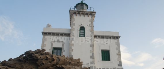
Ο φάρος κτίστηκε το 1887 από τη Γαλλική Εταιρεία Φάρων. Το 1941 καταστράφηκε από τους Γερμανούς και λειτούργησε πάλι το 1945. Στο μέσον της κατοικίας των φαροφυλάκων υψώνεται τετράγωνος πύργος ύψους 10 μέτρων. Η φωτοβολία του είναι 14 μίλια με εστιακό ύψος 60 μέτρα. Λειτουργούσε με πετρέλαιο, αλλά τώρα συνδέεται με το δίκτυο ηλεκτροδότησης.
Απολαμβάνουμε την όμορφη θέα προς τα νησιά της Μυκόνου, της Δήλου, της Τήνου και της Σύρου και είτε συνεχίζουμε στις άλλες διαδρομές του Πάρκου, είτε παίρνουμε το δρόμο της επιστροφής, αν η ώρα είναι περασμένη.
Αν έχουμε χρόνο όμως, επιστρέφοντας από τον φάρο, φθάνουμε στην παράκαμψη για το Πάρκο των Βράχων ή περιοχή των Ανεμόβραχων και ακολουθούμε δυτική πορεία. Η θέα Δ-ΒΔ προς τα νησιά παραμένει σπουδαία, αλλά αυτό που εντυπωσιάζει εδώ είναι η διαδρομή μας ανάμεσα σε λιθοφαγωμένους βράχους, πέτρινες μορφές που θυμίζουν κεφάλια αλόγων, κρανία πιθήκων, ράχες λευκών δελφινιών, κοκκινωπές σκορπίνες: πετρώματα πυριγενή ή εκρηξιγενή, όπως οι γρανίτες, μεταμορφωμένα όπως οι γνεύσιοι, οι σχιστόλιθοι, τα μάρμαρα, οι κερατόλιθοι και ιζηματογενή όπως η άμμος, οι ψαμμίτες και το χώμα. Η επίδραση της αποσάθρωσης, η αιολική διάβρωση και η διάβρωση από τα κύματα και το αλάτι δημιούργησαν μορφές που έχουν ποικίλα, απρόσμενα σχήματα.
Σκαρφαλώνοντας ανηφορίζουμε κι αρχίζουμε να στρεφόμαστε πάλι ανατολικά, απολαμβάνοντας την θέα της υπέροχης, απόκρημνης δυτικής ακτής της χερσονήσου και της βόρειας ακτής της Πάρου. Σιγά-σιγά, ξετυλίγεται πάλι μπροστά μας όλη η έκταση του Πάρκου με το Μοναστήρι και το καρνάγιο να προεξάρχουν. Ειδικά την ώρα του ηλιοβασιλέματος, το τοπίο αποκτά χρώματα έντονα και λαμπερά: τα βράχια, αλλά και τα κτήρια, παίρνουν αποχρώσεις από το χρυσό έως το πορφυρό και ιώδες.
Κατηφορίζοντας, επιστρέφουμε στο σνακ-μπαρ, όπου ολοκληρώνουμε τη διαδρομή μας, αφήνοντας τις εικόνες και τις ενθυμήσεις των αισθήσεων να συνεχίσουν την πορεία τους στο μυαλό και την ψυχή μας.
Επιμέλεια κειμένου: Χριστόφορος Κοροβέσης
The footpath as a «talking way»: A 'magic hour' eco-tour in Paros Environmental & Cultural Park
As we reach the Park peninsula, at the end of the road to Kolymbithres, we come by the small shipyard, the Aghios Ioannis Detis Monastery, the Katholiko beach with its seaside amenities and snack-bar, as well as the open-air theatre built on the rocks and the exhibition area, which host music concerts and events, exhibitions, lectures and film showings.
Walking through the Aghios Ioannis Detis peninsula is like making an itinerary that begins in pre-historic times and spans through the centuries to the end of the 19th century, when the stone-built lighthouse was erected in the island's northernmost cape, Korakas ('Crow').
There are many beaches in the Park, some nearer and others further away, little inlets and caverns, but also the Lighthouse and the remains of the Russian fleet installations during the Orloff occupation and the Russo-Turkish war (1770-1774); everything is accessible through easy footpaths, suitable for all ages that make up seven walking routes approx. 7 km. long. One of the footpaths starts from the Aghios Ioannis Detis yard. The name of the location is mentioned in seafarer's maps as early as 1530. The Monastery was however closed down by order of the first Regent of Greece in 1833. Nowadays, it is open once a year (29 August) with an all-night mass to celebrate its patron saint, St. John the Forerunner, the 'Detis' , who, according to the lore, was believed to cure ("δένει" - 'tie up') the ills of the malaria that would plague the inhabitants of Naousa in older times.
Footpath No. 1 continues on the opposite side of the paved road and gently climbs the low hill west of the monastery. The remains of settlements dating to the early archaic period (8-7th c. BC) were discovered at this location, which offers a vantage point over the entrance of the bay of Naousa.
We go past a small hill to the North, then downhill to approach the Diakofto inlet. At its right side, we can admire a gigantic rock with big slabs in many hues of gray and brown.
We continue along a gently rolling way and pass a small stone bridge. This is the Kapparies ('the caper plants') location, where we find ourselves in a typical Cycladic landscape with low-lying bushes, rushes and brushwood. Low annual rainfall, a long summer, an immediate border to the sea and strong winds prevent luscious vegetation growth. Nonetheless, especially in spring, always early in the year in the Cyclades, rich, colourful flowers abound: heather, wild orchids, amaranth, pennyroyal, caper, hedgehog-heath, mandrake, wild violet, stamnagathi (spiny chicory), lupine, mallow, dandelion, wild chicory, white thyme, Spanish oyster thistle, plain thistle, sweet pea, mustard plant, bearsfoot, sow thistle are just some of the respective plant names.
After the little bridge, the footpath continues uphill, goes by a small cave and twists to the west before reaching the Alonaki tis Dysis ('Threshing floor of the West"). This spot is 15 min. away from the monastery and the threshing floor has now been turned into the stage of a stone-built theatre, offering great sunset views to spectators and walkers alike, with the sun going down into the sea somewhere in between Syros, Serifos and Sifnos.
The endless vista includes the shipyard, the monastery on the 'neck' of the small isthmus, the white-washed houses of Naousa across the bay, and to the left, out to the northeast, Naxos town and Mount Zas, the highest peak in the Cyclades.
From Alonaki, we can continue our walk to the small hilltop of Voynali tis Syras, with a beautiful view to Syros Island, or further on to Cape Korakas, with its beckoning light house.
On a northbound route now, we continue along the old footpath to the lighthouse, enjoying great sea views on either side, as well as the sight of strange, impressive rock formations.
The Cape Korakas Lighthouse was built in 1887 by the French Lighthouse Company. It was destroyed in German air raids in 1941 and was repaired and put back to operation in 1945. Originally fuelled by oil, the lighthouse now runs on electric power. It has a basic rectangular shape: a a square 10-meter-high tower on top of the square keepers' quarters. Its beam has a range of 14 nautical miles, with a focal height of 60 m. The view is magnificent in every direction. To the N-NW, we can easily distinguish Mykonos, Delos, Tinos and Syros and on a clear day we might see as far as Evia.
Leaving the lighthouse, we may either take the path back or, if we have the time, reach the junction to the Rock Park and go south. The view W-NW remains great, but what captures our imagination are the wind-swept, sculptured rock formations we come across en route, with shapes that are reminiscent of horse heads, monkey skulls, dolphin backs or other sea creatures, made of various types of rock: igneous or magmatic rocks such as granite, metamorphic ones such as slate, schist, gneiss, marble and chert, sedimentary ones like sand, sandstone and earth. It is an ongoing natural sculpture workshop: weathering and erosion by the wind and sea salt though the centuries have created these uniquely shaped formations.
Scrambling uphill, we start heading east again to the Park's entrance, taking in the sight of the craggy western side of the peninsula and the rugged cliffs of the north-western shores of Paros. Slowly, the full expanse of the Paros Environmental Park is unfolding in front of our eyes, with the Lighthouse, the Monastery and the shipyard standing out. Particularly during the 'magic hour'* and sunset time, the landscape takes bright, intense hues ranging from golden to purple. It is the unique, unforgettable sunset of the Cyclades, an even more intense experience in summertime.
Ending our route in the Park, we go downhill in the direction of the snack-bar, where our route ends, letting images and the experience s of our senses settle in our minds and hearts and continue their journey within.
- Edited by Christoforos Korovesis
*An hour or so before sunset is commonly referred to as 'the magic hour' or 'golden hour' by photography buffs.
Le sentier-temoin d'une longue histoire: une eco-randonnée dans le Parc de Paros
En arrivant au Parc Ecologique de Paros, au bout de la rue vers Colibithres, on rencontre des chantiers naval, le monastère de Saint-Jean Detis, la plage Katholiko organisée avec le café-bar ainsi que le magnifique théâtre en plein vent bâti sur les rochers et le lieu d'exposition ou on accueille des manifestations musicales, des expos, des conférences et des projections.
Quand on traverse la péninsule de Saint-Jean c'est comme si on faisait un itinéraire des l'époque préhistorique jusqu'a la fin du 19 siècle, le phare a été achève il a été construit en pierres au le nord de l'ile, a cap Korakas.
A travers sept sentiers de randonnées, de sept kilomètres environ, se trouvant tout au long du parc, les piétons ont la possibilité de découvrir des plages de sable fin, des grottes, de petites baies mais aussi le phare a Kavo-Korakas et les installations maritime Russes pendant la période de guerre avec le Turcs (Orlofika, 1770-1774).
En été surtout, les randonnées deviennent plus agréables du moment que le paysage est baigne des couleurs lumineuses.
Un des sentiers commence par la cour du monastère de Saint-Jean de Deti. Ce toponyme se réfère déjà aux manuscrits de 1530. En 1883, selon la loi en vigueur de la régence d'Othon, les moines ont du abandonner le monastère.
Le 29 Aout le monastère jouit d'une grande fête, celle de Saint-Jean de Prodrome
Le nom "Detis" provient de la capacité du Saint de guérir le paludisme du 18ieme au 19ieme siècle qui tourmentait les habitants de Naoussa.
Le premier sentier prend la montée jusqu'a la colline a l'ouest du monastère. A cette position qui offre la possibilité de contrôler l'entrée dans le golfe de Naoussa, on à découvert des ruines de bâtiments dates du période archaïque (8-7 siècle av. J.-C.).
Apres la petite colline dans le nord, on descend et on trouve la baie de Diacofto et a droite il y a un grand rocher avec toutes les couleurs de terre. On continue en passant un petit pont en pierre et on arrive a Kaparies dans un local paysage des Cyclades avec des buissons et des plantes sauvages. Les pluies rares, le long été, le voisinage avec la mer et les vents empêchent la végétation de se développer. Malgré tout, les couleurs des fleurs surtout le printemps qui arrive tôt sur l'ile, sont riches et varies.
Apres le petit pont, le sentier remonte, on passe par une petite grotte et a quinze minutes du monastère, on arrive a Alonaki qui se trouve a l'ouest. Les piétons peuvent admirer le théâtre en pierre qui impressionne tout le monde par le coucher de soleil entre les iles Serifos, Sifnos ,Siros.
La vue est magnifique: les chantiers naval, le monastère de Saint-Jean, la ville pittoresque de Naoussa avec les maisons blanches et a gauche dans le sud-est, la ville de Naxos et Zas, la plus haute montagne des Cyclades.
Apres Alonaki, la randonnée se continue soit vers le petit sommet Vounali de Siros soit vers le phare de Korakas. Tous les deux on une vue impressionnante.
On continue vers le nord en remontant le sentier parmi les plus beaux rochers et on arrive au phare de Korakas. Le phare a été bâti en 1887 par la compagnie française des phares. En 1941, il a été détruit par les raids allemands et on l'a reconstruit en 1945.Au milieu de la résidence des gardiens du phare, il y a une tour carrée de 10 mètres. Le phare émet sa lumière a une distance de 14 kilomètres et a une hauteur de 60 mètres. Il fonctionnait a l'aide du pétrole mais désormais il est branche au réseau de l'électricité.
On jouit d'une vue splendide donnant sur les iles de Mykonos, de Delos, de Tinos, de Siros et on continue aux autres trajets du parc ou si l' on veut, on prend le chemin de retour.
Si on a du temps, en rentrant du phare, on arrive a la déviation vers le parc des rochers autrement dit la région des Anemovrachi et on se dirige vers l'ouest. La vue reste remarquable mais ce qui impressionne le plus, c'est l'itinéraire entre les rochers, les figures en pierre qui ressemblent à la tête d'un cheval, à des singes, à des dauphins et a des rascasses rouges.
On peut aussi voir des roches créées par l'explosion des volcans, comme les granits, les ardoises, les marbres et des roches sédimentaires comme le sable et la terre. Toute la région se constitue surtout des roches granitiques. L'altération due au vent et aux vagues de la mer a crée des figures des formes diverses.
On remonte vers l'est en jouissant de la vue de la cote abrupte de la peninsule. Peu a peu, on voit devant nous le parc avec le monastère et le chantier naval. Le coucher de soleil colore le paysage avec des couleurs exceptionnelles des nuances de l'or au rouge.
On descend et on retrouve le café-bar ou notre randonnée se termine en gardant en tête les meilleurs impressions et souvenirs pour retourner encore une fois dans se Parc merveilleux!!!
Christoforos Korovesis


")
")
")